
Tropical Storm Kiko is churning west across the open Eastern Pacific, organizing over warm water with favorable upper-level winds. As of the latest National Hurricane Center (NHC) advisory issued this morning, Kiko is a compact, steadily strengthening system well away from land, and forecast guidance calls for additional intensification over the next couple of days.
While no coastal watches or warnings are in effect and there is no immediate land threat, the storm bears close attention from mariners along common east-to-west routes and from weather watchers in Hawaiʻi monitoring the longer-range pattern.
Current Status at a Glance
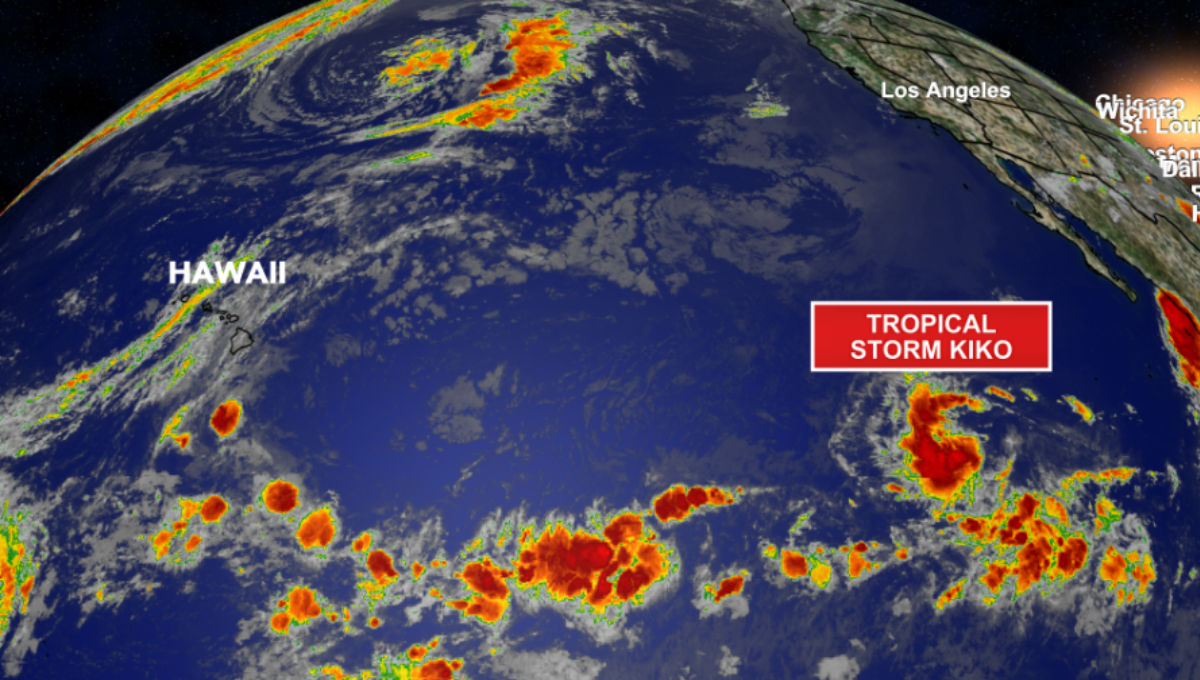
The most recent NHC package places Kiko’s center over the open ocean southwest of the Baja California Peninsula, moving generally west at a modest pace. Maximum sustained winds are at tropical-storm strength, with higher gusts, and the central pressure supports a healthy, consolidating core.
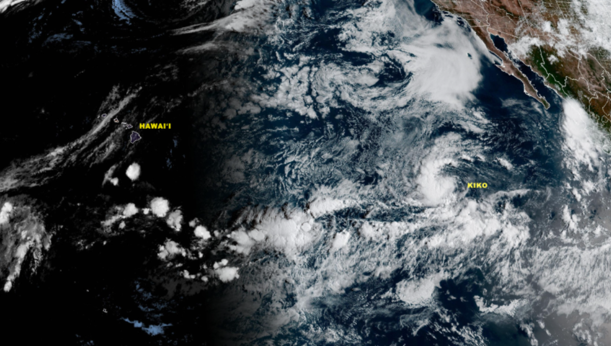
Satellite loops show curved banding wrapping into a tight center, with the most persistent convection on the southern and western flanks—classic signs of a small storm finding its balance.
Why Kiko Is Strengthening
Two ingredients are working in Kiko’s favor right now. First, vertical wind shear—the change in wind with height that can tear storms apart—remains relatively light. Second, sea-surface temperatures along the near-term track are warm enough to fuel deep thunderstorms.
That combination often allows compact Eastern Pacific storms to tighten their inner cores and step up in intensity, sometimes faster than models anticipate. Forecasters note that a period of faster strengthening can’t be ruled out through mid-week if the core stays intact and dry air remains at bay.
Official Intensity Outlook
The NHC forecast calls for additional strengthening and makes Kiko a hurricane within roughly 24–36 hours if current trends hold. The consensus peak is in the Category 1–2 range later this week, before environmental checks—slightly cooler waters and pockets of drier mid-level air—likely temper the climb.
Remember that intensity forecasts carry more uncertainty than track forecasts; small, well-organized storms can surprise to the upside or stumble if their eyewall attempts fizzle. The safest approach is to track updates every six hours as new satellite and reconnaissance data (if tasked) feed into the forecast.
Track Forecast and Cone Guidance
Kiko’s steering flow is straightforward in the short term: a mid-level ridge to the north is guiding the storm generally west to west-southwest along a narrow latitude band near 14°N. The official track keeps the center over open water through five days, trending farther from Mexico with time.
Beyond Day 5, guidance diversity grows as the storm approaches the longitudinal boundary where the Central Pacific Hurricane Center (CPHC) takes over responsibility if the cyclone crosses 140°W. The practical takeaway: Kiko remains a marine concern first and foremost for now, not a coastal one.
Hawaiʻi: Early Read, Low Confidence
Mention “Kiko” and Hawaiʻi in the same sentence, and ears perk up—for good reason. Systems that survive the Eastern Pacific and trek west naturally raise questions about the islands. At this stage, though, the Hawaiʻi discussion is low-confidence and beyond the NHC’s five-day window.
Some model members keep Kiko (or its remnant energy) south of the island chain; others curve the track or weaken the system over marginal waters. The most honest guidance is this: there is no direct threat signal within five days, and interests in Hawaiʻi should simply check the forecast once or twice a day until the scenario becomes clearer.
Marine Impacts and Who Should Care Right Now
Even storms far from land shape the sea. For vessels transiting between the Mexican Riviera, Clipper routes near 130–140°W, or mid-Pacific lanes toward the central basin, Kiko’s gale-force winds and rough seas extend outward from the compact core, especially in the storm’s stronger semicircle.

Marine planners should build in time and distance buffers around the forecast track, check the wind radii listed in advisories, and leverage altimeter and scatterometer passes when available for real-time sea state clues. If your route intersects the cone, plot contingencies now rather than later.
Satellite Story: What the Clouds Are Saying
GOES-18 infrared and visible “floater” imagery paints a picture of a small cyclone learning to breathe more steadily. You’ll notice bursts of very cold cloud tops firing near the center, then wrapping into a tighter comma shape. That pulsing—sometimes called convective cycling—often precedes an inner-core consolidation, which is step one toward hurricane strength.
Watch for improved symmetry, more consistent outflow aloft, and a shrinking central dense overcast. Those signs typically foreshadow sustained intensification if the environment cooperates.
What Could Change the Forecast
Two wild cards deserve mention. First, dry mid-level air lurks to the northwest; a small ingestion can erode the eyewall, forcing Kiko to rebuild and sapping momentum. Second, marginal sea-surface temperatures lie farther west; once the cyclone crosses the 26 °C isotherm for long stretches, the heat engine cools. Either factor could cap the peak or hasten weakening after mid-week.
Conversely, if shear stays light and the core clicks, short spurts of rapid intensification remain on the table. That’s why the phrase “subject to change” isn’t hedging—it’s honest science.
Preparedness: Smart Moves for a Low-Threat, High-Interest Storm
For coastal communities, Kiko is a weather curiosity rather than a worry—for now. Still, travelers and boaters can make a few smart moves:
- If you sail: Update voyage plans using the latest advisories; add a conservative buffer to the strongest quadrants and account for swell timing that often outlives the wind field.
- If you fly: Long-haul Pacific routes occasionally nudge around convective clusters; build wiggle room into connections.
- If you’re in Hawaiʻi: Keep a casual eye on the outlook mid-week. Long-range model chatter is not a forecast; rely on official updates as the system advances.
Naming Note to Avoid Confusion
The name “Kiko” also appears on the PAGASA list for the Philippine Area of Responsibility (PAR). If a separate Western Pacific disturbance were to develop near the Philippines, it could be called Kiko locally as well. That would be a different storm entirely, managed by a different agency, even if the names match. Always confirm the basin and the agency issuing the advisory when you share updates.
How Often to Check for Updates
Tropical systems are living things. The best way to stay oriented is to glance at official bulletins during the standard cycle: every six hours (typically around 03Z, 09Z, 15Z, and 21Z) with intermediate public updates if changes warrant. That cadence ensures you catch any jogs in track, pulses in intensity, or shifts in the environment.
The Bottom Line
Tropical Storm Kiko is a compact, strengthening cyclone tracking west over the open Eastern Pacific. Forecast guidance supports a hurricane within about a day to a day and a half, followed by a peak in the Category 1–2 range before environmental limits trim its power later in the week. There are no coastal watches or warnings, and no immediate land threat.
For now, Kiko matters most to mariners navigating its path and to Hawaiʻi as a system to watch, not worry about, beyond the five-day window. As always, lean on official forecasts and keep an eye on the next advisory—tropical weather rewards the patient and the well-informed.
For the authoritative forecast track, wind radii, and discussion, consult the National Hurricane Center’s official page: National Hurricane Center.